Topolines turns any real place on Earth into a clean topographic contour map. You pick a location on the map, it pulls the actual elevation data for that spot (SRTM 30m, or 10m GeoTIFF for finer terrain), and generates the contour lines from it. So the ridge you export is a real ridge, not a shape you drew.
I built it to solve a recurring friction in my own design work: getting vector topographic maps without opening heavy 3D software or rebuilding them by hand in a vector tool.
From there you can tweak contour density, line weights, the elevation taper and colors, then export as clean SVG or HD PNG, ready for Figma, web, or print.
Try it on somewhere you know well, that's when it clicks. I'm around all day for questions and feature requests 🙌
@Alexis that's a genuinely useful caveat most "10m DEM" products don't bother explaining - the grid resolution vs actual survey fidelity distinction matters a lot for anyone picking a spot outside the US/Europe expecting the same crispness. would be a nice touch if the tool flagged which source tier a given region falls back to before someone pays for a poster of it, so they know what they're actually getting up front instead of finding out after printing.
I am completely obsessed with this app. I've been hiking in the LA area for 3 years now with a really weak angle. I'm able to assess depth over distance swiftly and decide if I can make it down or up super steep mountainsides. Both me and my ankle thank you 🫡
The contour generation actually looks smooth and respects the drawn zone boundaries properly, not just a sloppy clip mask. That gradient-to-line opacity taper is the kind of detail that makes it feel made for real cartography work, not just a tech demo.
using real SRTM elevation data instead of just letting you doodle contour-looking shapes is what makes this actually useful for real design work, not just a pretty toy. how fine does the 10m GeoTIFF option get in practice - is that resolution available everywhere on Earth, or only for certain regions where that survey data exists?
Seeing a few comments about drawing or sketching zones, so a quick clarification for anyone landing here: there's no freehand drawing in TopoLines. You pick a real location on a map and the contours are generated from actual elevation data (SRTM 30m, or 10m GeoTIFF on paid). The terrain you export is a real place, not a shape you drew. Happy to answer anything else.
the gradient control on the elevation taper is genuinely thoughtful, gives you that subtle handmade cartography feel instead of looking like a flat computer readout. love how clean the SVG export is too.
Adding a quick elevation labeling option directly on the contour lines would save a ton of time, especially for detailed terrain work where you need to identify specific altitudes at a glance without opening a separate legend.
It would be great if you could add an option to import an existing SVG or image so we can trace over real terrain data instead of having to draw zones from scratch every time.
Love how clean the export looks and the Figma output is a huge plus for my workflow. One thing that would save me a ton of time is letting me save custom gradient presets tied to elevation ranges, so I can quickly reuse the same color scheme across multiple terrain projects without re-tuning each one.
Love how the elevation taper keeps the contours feeling organic instead of mechanical. The Figma-ready SVG output is a really thoughtful detail for designers.
Honestly the gradient and elevation taper feature is super useful, way better than other tools I've tried. Exported SVG dropped cleanly into Figma without any cleanup.
Drew a quick test zone and the contour output came back surprisingly clean, with smooth gradients and crisp lines ready to drop straight into Figma. The SVG export saved me a ton of cleanup time.
Would love a way to import a simple list of elevation points or a CSV so I don't have to draw zones manually when I already have survey data. That would speed up my workflow a ton.
The contour generation is impressively clean for such a quick draw, and the elevation taper really makes the depth read well. Exporting straight to a print-ready SVG saved me a ton of cleanup.
The elevation taper setting is such a thoughtful touch, it keeps the contours from feeling flat at the edges. Clean Figma export is the cherry on top.
Love that the elevation taper actually shows up in the exported SVG, makes the contour map feel tactile rather than just flat geometry.
Drawing a freehand zone and watching the contours snap out so cleanly was a nice surprise. The HD PNG export is already perfect for dropping straight into a deck.
Honestly kind of surprised how clean the contours came out, even when I scribbled a messy zone. The Figma-ready export saved me a bunch of fiddling.
The zone drawing UX is genuinely satisfying, feels closer to sketching than configuring software. Love that the contour output drops straight into Figma without a cleanup pass.
About Topolines on Product Hunt
“Generate Topologic contours”
Topolines launched on Product Hunt on July 21st, 2026 and earned 143 upvotes and 57 comments, placing #12 on the daily leaderboard. Draw a zone, generate crisp topographic contour lines, and export print-ready SVG & HD PNG. Gradients, elevation taper and Figma-ready output.
Topolines was featured in Design Tools (263.3k followers) on Product Hunt. Together, these topics include over 45.7k products, making this a competitive space to launch in.
Who hunted Topolines?
Topolines was hunted by Alexis Oulès. A “hunter” on Product Hunt is the community member who submits a product to the platform — uploading the images, the link, and tagging the makers behind it. Hunters typically write the first comment explaining why a product is worth attention, and their followers are notified the moment they post. Around 79% of featured launches on Product Hunt are self-hunted by their makers, but a well-known hunter still acts as a signal of quality to the rest of the community. See the full all-time top hunters leaderboard to discover who is shaping the Product Hunt ecosystem.
Want to see how Topolines stacked up against nearby launches in real time? Check out the live launch dashboard for upvote speed charts, proximity comparisons, and more analytics.


 Alexis Oulès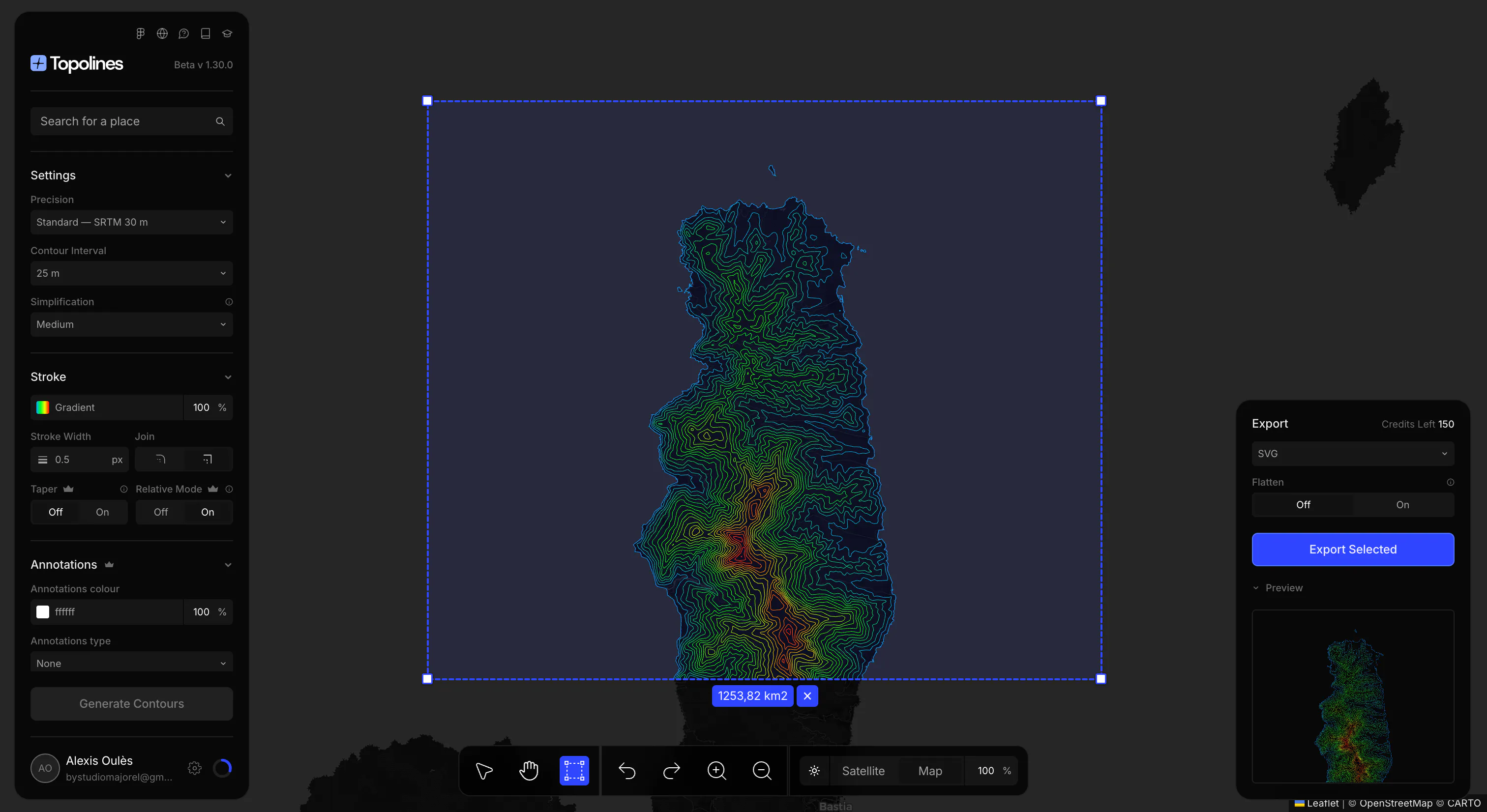
Hey Product Hunt! 👋
Topolines turns any real place on Earth into a clean topographic contour map. You pick a location on the map, it pulls the actual elevation data for that spot (SRTM 30m, or 10m GeoTIFF for finer terrain), and generates the contour lines from it. So the ridge you export is a real ridge, not a shape you drew.
I built it to solve a recurring friction in my own design work: getting vector topographic maps without opening heavy 3D software or rebuilding them by hand in a vector tool.
From there you can tweak contour density, line weights, the elevation taper and colors, then export as clean SVG or HD PNG, ready for Figma, web, or print.
Try it on somewhere you know well, that's when it clicks. I'm around all day for questions and feature requests 🙌