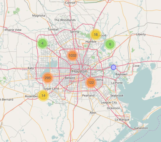
This map is populated by pulling tweets to rescue-related hashtags and accounts, parsing addresses, then geocoding them and putting them on a map so rescuers can locate people. We are interested in doing whatever we can to provide location data to organizations that need it, either for current rescue efforts or recovery.
Harvey Emergencies Map launched on Product Hunt on August 29th, 2017 and earned 74 upvotes and 0 comments, placing #20 on the daily leaderboard. This map is populated by pulling tweets to rescue-related hashtags and accounts, parsing addresses, then geocoding them and putting them on a map so rescuers can locate people. We are interested in doing whatever we can to provide location data to organizations that need it, either for current rescue efforts or recovery.
Who hunted Harvey Emergencies Map?
Harvey Emergencies Map was hunted by Michele Hansen. A “hunter” on Product Hunt is the community member who submits a product to the platform — uploading the images, the link, and tagging the makers behind it. Hunters typically write the first comment explaining why a product is worth attention, and their followers are notified the moment they post. Around 79% of featured launches on Product Hunt are self-hunted by their makers, but a well-known hunter still acts as a signal of quality to the rest of the community. See the full all-time top hunters leaderboard to discover who is shaping the Product Hunt ecosystem.
Want to see how Harvey Emergencies Map stacked up against nearby launches in real time? Check out the live launch dashboard for upvote speed charts, proximity comparisons, and more analytics.
 Michele Hansen